I always love a trip to the Buffalo National River located in North Central Arkansas just south of Harrison. It is a real outdoor jewel in our area and so thankful for all the hard and deliberate work that went in to keep this River from being dammed up decades ago. There are several different ways to explore and enjoy this area. The Buffalo River system is over 150 miles in total with well over 95,000 acres of land around to explore. You can camp, fish, hike, bike, float or trail ride various sections along the River and up into the canyons and mountains.
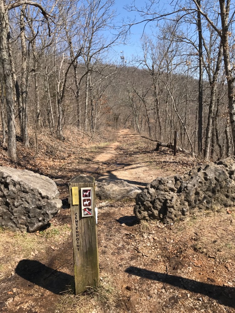
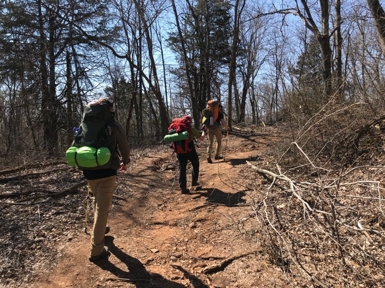
For this trip we decided to hike the Centerpoint Trail down to Sneeds Creek for a 3 day / 2 night backpacking trip. This section is about 4 miles down hill, 1100 feet. My pedometer said it’s about 65 flights of stairs down. We strapped on our nearly 40 pound packs and took off Friday around noon from the Centerpoint trailhead which is north of Ponca a couple miles on Hwy 43. The trail follows an old road most of the way down that is easy to follow. It’s all down hill, with a couple sections quite a bit steeper than others.

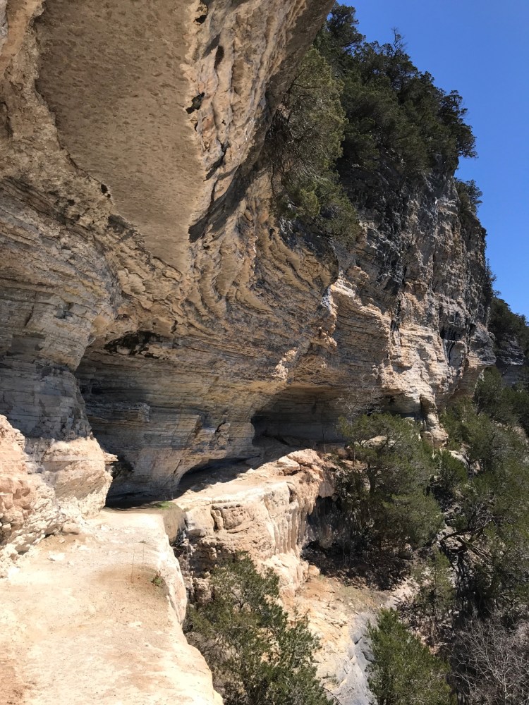
At about the half way point, 2 miles, you can stop and drop your packs and take the trail to the right and slack pack along the Goat Trail to Big Bluff. This is a little over a one mile spur out and back that gives you a very rewarding view of the Buffalo River and the river valley. It is breath taking for more than one reason. It’s not for the faint of heart as you are out on a Bluff over 300 hundred feet above the river floor. The entire Bluff is over 500 feet and is said to be the tallest sheer Bluff face between the Rockies and the Appalachians. The walking area is fairly narrow out on the Bluff, so please be careful. All the literature has warnings about the possible danger in this area, and I echo that as well. I wouldn’t take kids on this spur. It’s just too easy to have a problem and would have just about any parent a nervous wreck the whole time. It’s hard to believe that school kids used to use this trail to go to the school house at the bottom of the Bluff which you can see hidden in the trees down near the river. It’s beautiful and worth it, but please be careful.

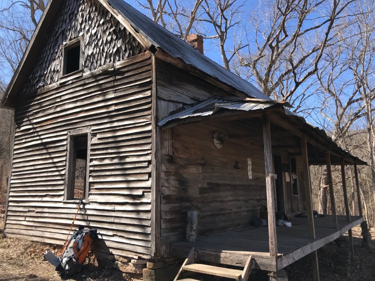
After taking a break out on the Bluff and taking in the views we walked back and picked up our packs and headed down the hill. The next great stop is at Granny Henderson’s cabin about 1.5 miles further down the hill. It is said that she was the last person to live within the park boundaries in the river valley. The cabin is so neat to explore and to stop and think about the life this place lived. So primitive and awesome. We took a break here to take it all in and just think. So nice.

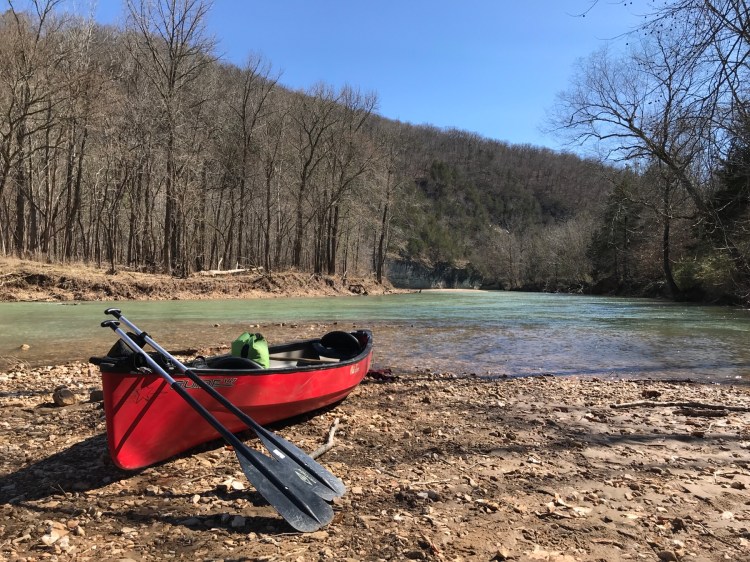
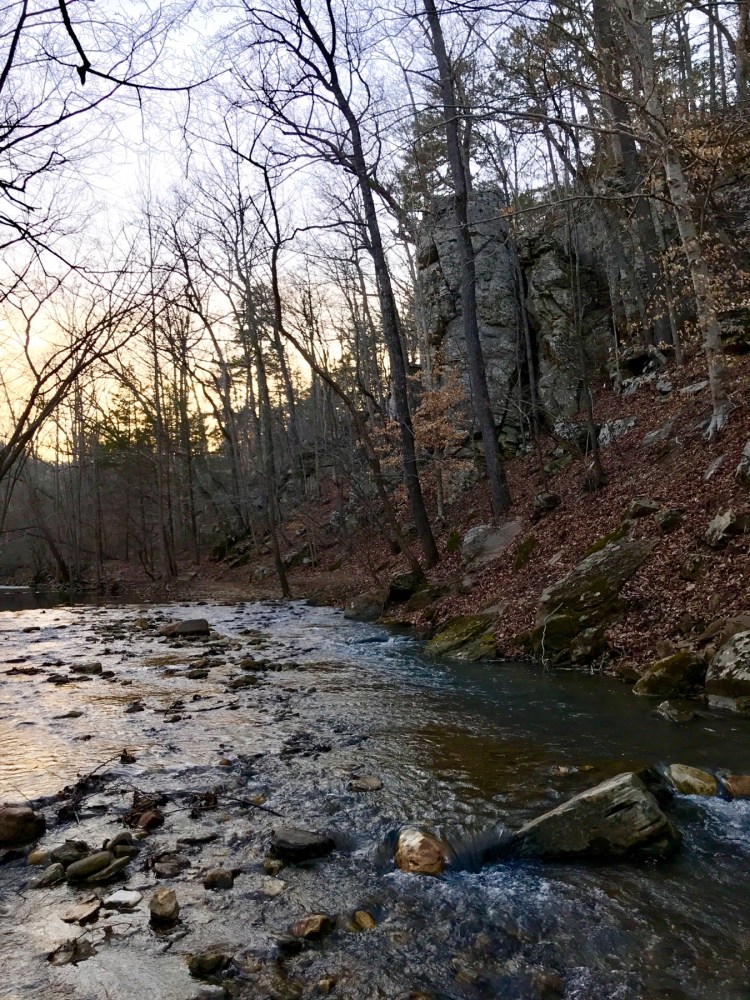
From Granny’s we hiked a half mile thru the trees down to where Sneeds Creek enters the Buffalo River. Sneeds Creek is a small seasonal Creek that doesn’t have water flowing that often. After a good rain it will be flowing and even then it’s usually minimal. It was flowing about 6 inches max when we were there. The Buffalo River was at flood stage just a day before to give you a reference of the water flow difference between this Creek and the Buffalo River. But as always, use caution if you know rain is expected in the area as the drainage area these tributaries support are pretty large and they can have flash floods. As I mentioned before, the Buffalo River is over 150 miles long, so depending where you are you need to be conscience of the potential rain hundreds of miles away. It may be perfectly sunny day where you are, but there could be a huge rain storm 50 miles away that is draining right down into these canyons your hiking. It is a pretty weird phenomenon that can be dangerous if you don’t pay attention.
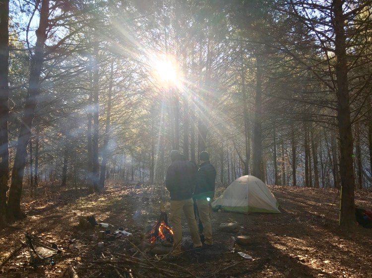
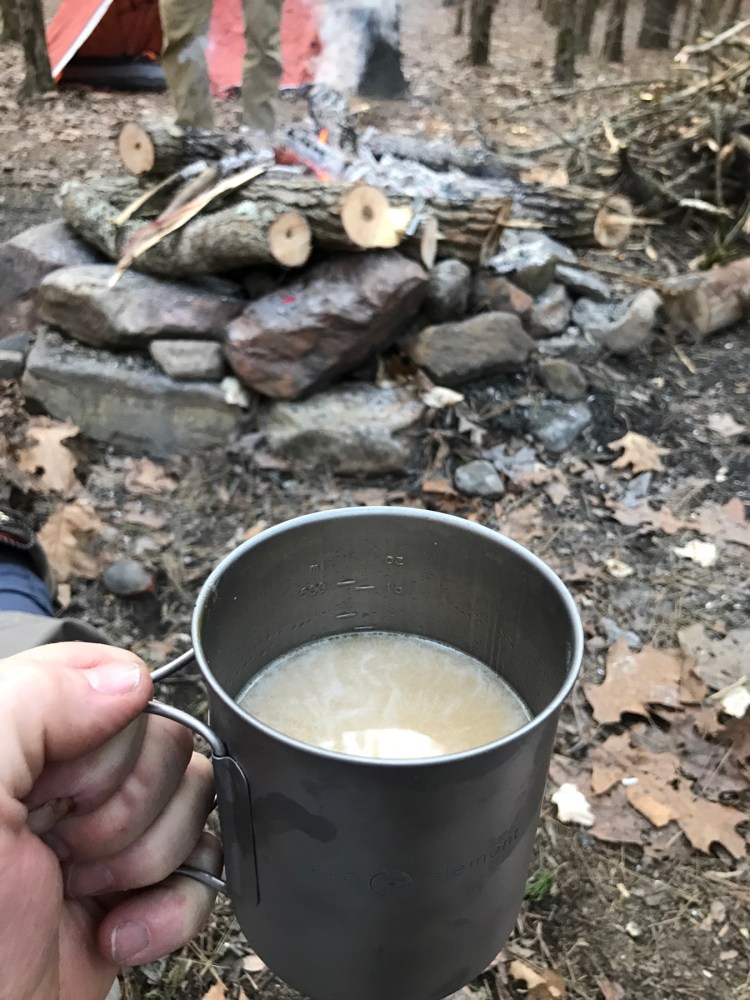
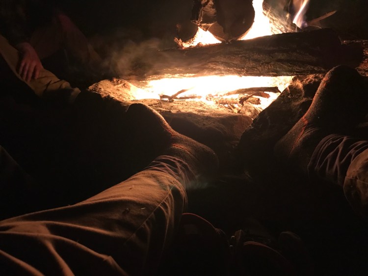
Once we reached this area we searched for an optimal camping spot that was shielded from the wind. The day we were there the wind had calmed down to 10-15 mph and the low temperature that night was expected to be in the 20’s, so we didn’t want to add wind to our potential misery. We found a nice place with an established fire ring and setup camp. We then took some time to explore along the Buffalo River and filter some drinking water. There were a few places along the trail down that had running water, but I’m not sure how long they flow after a rain. So if you’re only going to the Goat Trail make sure to have enough water for your round trip. After we got our water replenished we gathered some wood to prepare for a very cold night. It was about 4pm when we finally sat down around a nice warm fire and watched the sun set through the trees and marveled at how the temperature dropped as the sun dropped. We cooked our meals around the fire on our fuel stoves and had some great conversations solving the worlds problems. The fire was warm, but the temperature steadily dropped every hour. I eventually had to stand and rotate like a rotisserie chicken to keep my whole body warm. Whichever part of my body was away from the fire got pretty chilled. We finally decided to hit the hay around 10:30pm. My 20 degree bag was pretty warm to start the night which was comforting. At about 5:30am my feet got cold and not too much after that my right foot felt frozen. My feet always get cold, but this right foot was miserable. I was able to grind out another 2 hours of shuteye and rolled out of bed around 7:30am to my friend stocking up the fire. I got my stove going and got a nice cup of hot coffee going in just a few minutes. That was such a delicious and comforting cup of Joe. We sat around the fire and watched the sun rise over the mountains and fill the river valley with beautiful warm sunlight. In just over an hour or so the temp had raised considerably and felt a very comfortable cold. Temperature was still somewhere in the upper 30’s, but it felt good. We ate various breakfast items and planned out our adventure for the day.


On Saturday we decided to go view the Hemmed In Hollow waterfall. This waterfall is over 200 ft tall and is the tallest waterfall between the Rockies and the Appalachians. During the raining times there is a nice flow of water coming over the falls. Not sure of the rate, but it wouldn’t take very many seconds to fill up a 5 gallon bucket. During the fall time frame the water flow is just a trickle and would take several minutes to fill up a 5 gallon bucket, just to give you a perspective of the difference in the water rate. The falls are easily accessible from the top by way of The Compton Trailhead. It’s easy to get there, but a very strenuous hike from this trail. You can also access the falls from the Buffalo River as a great stop on a float trip which is the easiest hike. You can also access from the Old River Trail by taking a small spur over to the trail, but you will have a river crossing. If you are on the Old River Trail you will have several crossings no matter if you start up stream at Steel Creek or downstream from Kyles Landing so one more shouldn’t break the bank. Since the Buffalo River was up and the temperature pretty cool we decided we didn’t want to cross the Buffalo River. We reviewed our map and it didn’t seem to hard to get there without having to cross the River. We crossed Sneeds Creek by hoping on rocks and went looking for the trail. We took the trail up Sneeds Creek and the trail just kept climbing up and away from the falls area. So we all decided that wasn’t the right way. So we went back to the mouth of Sneeds Creek and the Buffalo River. We took the trail to what we think is the Centerpoint school house foundation and kept walking past that. The trail fairly quickly disappeared and then we began to bushwhack through the hills towards the fall. We should have turned back, but we pressed forward. Navigating through the Forrest was pretty easy with all the leaves off and all the under brush dead, but not the best idea. We finally intersected with the main trail into Hemmed In Hollow and followed it the rest of the way into the fall. The fall was beautiful. I never get tired of seeing this site no matter what the water flow is. After sitting around for awhile and taking in the site we decided to head back to camp. We stayed on the main Hemmed In Hollow trail and found the intersection to the trail we first were on that we thought was wrong. If you take a right going up you go to the Compton Trailhead and if you go left you go into Sneeds Creek. We took the left and followed it down into Sneeds Creek and hoped across on some rocks and headed to camp.

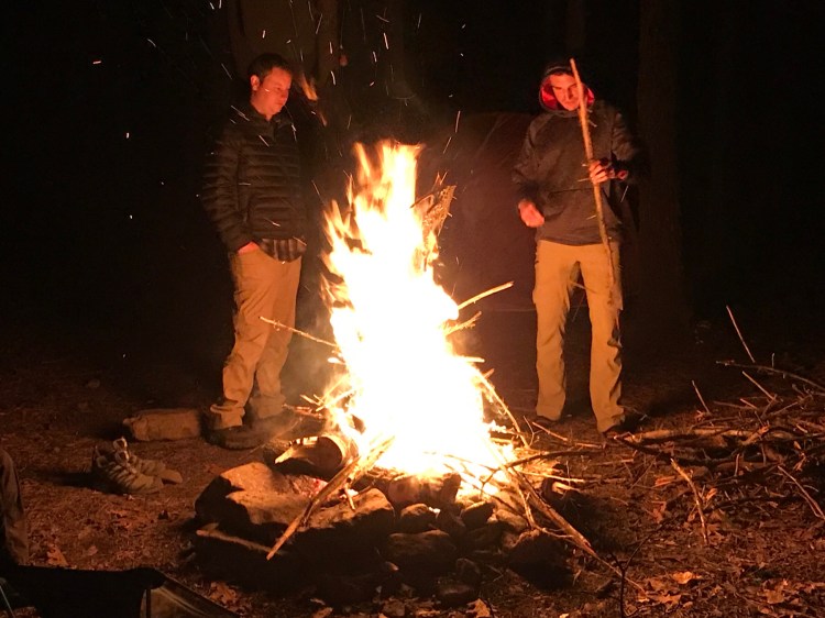
We got back to camp around 3pm and then filtered some more water, collected some more wood and just hung out and threw rocks and hit rocks like we were a major leaguer. Just good fun. We made a fire and cooked a nice hot meal and hung out. My pedometer said we walked over 6 miles and climbed 70 flights of stairs this day. That hike into Hemmed In Hollow is pretty steep and we didn’t do half of the climbing you do using the full Compton Trail. We all went to bed around 10pm, pretty tired from 2 days of hiking and a restless sleep from the cold the prior night.


Saturday night wasn’t nearly as cold with lows in the mid 30’s. It was much more comfortable to sleep except for the sore muscles starting to creep in. We all got to the fire around 7:30 am again and had some coffee and breakfast. We slowly broke down our camp and started back up the hill around 10:30am. We took it nice and slow and took several nice breaks and made it back to the Centerpoint trailhead covering the 4 miles in 2hrs. I was surprised it was that quick because we really took it easy and used a nice, slow and steady pace.


Overall these 3 days we hiked about 16 miles with 8 of those with a pack. It was such a great trip and I enjoyed it so much, but I can’t remember having a bad Trip to the Buffalo River. Hope this information helps you on your next great journey.
Stay Trout Tough!
Erik
